
Mobility Solutions for BMW-Group: Development of a Mobility Accessibility Index (MAI)
- contact:
- funding:
BMW Group
- start:
2021
- end:
2022
Problem Statement
The quality of public transport services varies for different spatial areas. In this context, the simple pedestrian access to bus or train stops is not enough for a comprehensive quality assessment. Two further aspects need to be considered: the availability of services including service frequencies and the number of different lines at a stop; the accessibility of relevant destinations within a certain travel time. For the overall evaluation of the quality of public transport services, it therefore makes sense to include all three aspects in the assessment. For presentation and easy comparability of spatial differences, a single indicator, which is specified for a certain level of aggregation (e.g. zip codes), is appropriate.
Objective
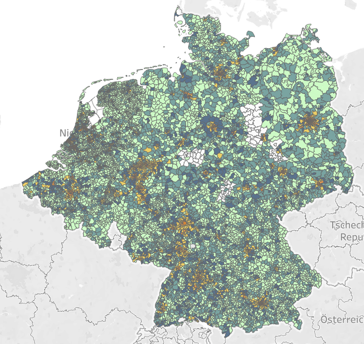
The overall objective of this project is the determination of a mobility accessibility index (MAI), which allows to describe the quality of public transport on a spatially aggregated level. For this purpose, an indicator is calculated at the level of postal codes by including different variables. In particular, the walkable access to stops, the availability of services at these stops and the destinations that can be reached from there are considered. The study areas are Germany, Belgium and the Netherlands.
Methods
For the assessment of the competitiveness of public transport compared to the private car, various methods were applied. Primarily GIS-based calculations, travel time isochrones and stop catchment areas are applied to calculate "transit indicators". The availability of public transport is considered by the number of departures at relevant times (e.g. morning peak hour), the density of departures on weekdays and weekends, and the service period. The basis for these calculations is the standardized GTFS (General Transit Feed Specification) data for public transport. The travel time isochrones are evaluated in terms of the number of destinations that can be reached within a certain travel time. The catchment areas are determined for different modes of transport (bus, tram/metro, rail, and long-distance rail). Cluster analytical methods are used to determine the number of quality levels. In addition, an AI-based algorithm is implemented that allows to assign the quality levels of the MAI to all postal codes in Germany, Belgium and the Netherlands.
Result
The MAI is available as an indicator with five quality levels and allows a differentiation of public transport services at the spatial level of postal codes.